Kriging
Advertisement
Isoliner v.1. 6. 2005
Isoliner is the ArcGIS extension for make grids and points theme with interpolate by Kriging's and triangulation method. Last version of extension include Slide Analyst as free function.
Advertisement
GS+ v.9.0.011
GS is a comprehensive geostatistics program that is fast, efficient, and easy to use.
OmniVar v.1.0
The variogram is a simple tool for analyzing spatial variability. When properly understood, the variogram will allow the determination of adequate sample spacing, and provide the model parameters required for kriging.
HPGL v.0.9.9
HPGL is designed to provide a free to use high perfomance geostatistics algorithms like Kriging, CoKriging, Sequential Sumulation, etc.
SADA v.4. 1. 1950
Spatial Analysis and Decision Assistance (SADA) is free software that incorporates tools from environmental assessment fields into an effective problem solving environment.
SuperGIS Spatial Statistical Analyst v.2.0
SuperGIS Spatial Statistical Analyst is a set of application software integrating geostatistical methods and GIS functions.
WinGslib v.1.5.0.6
WinGslib is toolbox of Geostatistical software algorithms written for Windows 95/98/NT. It provides a front-end to all the GSLIB programs.
Point Analyst v.1.0
Point Analyst is an extension to the ArcView® GIS designed for the exploratory analysis of spatial sampling and analysis methods.
ILWIS Open v.3.6.0.1
ILWIS Open integrates image, vector and thematic data in one unique and strong desktop package. It delivers a wide range of feautures including import/export, digitizing, editing, analysis and display of data,
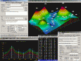
3DField v.3.7.3
This plotting software converts your data into contour maps and surface plots. It interpolates X, Y and Z data points onto a grid, orthogonally or within an arbitrary border. It also displays data points on a plane,
Geoblock v.2010.1.5 Build 124
An easy-to-use software for 3D modeling. The Geoblock software is integrated program for 2D/3D modeling, computational geometry and visualization of spatial datasets. The software can be used in Earth sciences particularly in such fields as survey,